Chesil Beach and the Fleet Lagoon
18 miles and 180 billion pebbles
Ferrybridge - WWII

During WWII there was considerable military activity around the Ferrybridge area. Click here to see a map of the location of the various activities described here.
As part of the anti-invasion measures the following happened:
- A number of pillboxes were constructed
- Demolition charges were placed under the road and rail bridges
- Anti-tank obstructions were placed across the beach
- A number of barbed-wire fences were installed
As part of the air defences of Portland Harbour three 40mm Bofors light anti-aircraft guns were installed, one on top of the beach, one by the railway line on Hamm Beach and one north of the Whiteheads works. They were supported by a heavy anti-aircraft gun battery on Barrow Rise on the high part of Wyke Regis.
Because of the danger that Ferrybridge could be bombed a second water pipeline to Portland was installed crossing the Fleet and then under the beach to rejoin the main pipe near the main road. A diversion was also built to allow road traffic to use the railway bridge with an access road alongside the Whitehead works on the north side of the Fleet and a road joining the railway line to the roadway on the south side of the Fleet.
The 1946 and 1947 aerial pictures of the Ferrybridge area show a large number of bomb craters across the area. The two largest on Chesil Beach can still be seen.
Later in the war, in the run up to D-Day in 1944, the area that is now the car park for the Visitors Centre was flattened and used for storing a large number of military vehicles ready to be embarked at Portland Harbour.
A large amount of pebbles were extracted from the beach to be used in the various construction projects associated with the D-Day preparations. The hollow left is now the lagoon that forms alongside the Visitors Centre car park
Throughout the war the area leading up to the Narrows and beyond was part of the Chesil bombing and air gunnery range.
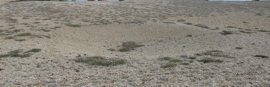
The bomb crater on Chesil Beach in 2025.
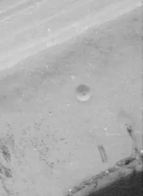
The same crater as it was in 1946
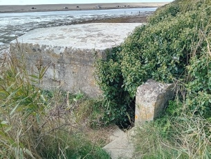
Type 22 pillbox on the shore of the Fleet