Chesil Beach and the Fleet Lagoon
18 miles and 180 billion pebbles
Ferrybridge - Pipeline

During 1940 it became apparent that with the many bombing attacks on Portland Naval Base and the Whitehead torpedo works there was a high probability that one or both of the Ferrybridge bridges could get hit. The road bridge also carried water and electricity to Portland. Whilst the electricity cable could be replaced fairly readily the loss of the water pipe was more serious.
In late 1940 a new pipeline was laid that crossed the Fleet from where the caravan camp is now over to Chesil Beach. It then ran under the beach parallel to the shoreline until it reached where the footbridge is now from the car park to the beach. The pipeline then swung left and crossed what is now the car park to join with the existing water main close to the roadway.
Later, a junction was installed near the end of the footbridge with a new extension pipeline installed that ran under the beach all the way to the pumping station in Victoria Square on Portland.
It is not known if the pipeline was ever used. The bridges were never damaged so there never a necessity to use it during the war. However, it may have been used in the 1980’s when the road bridge was replaced.

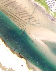
The above photograph was taken shortly after the end of the war. The route of the water pipe and its later extension is shown as an overlay. To view the original background picture in higher resolution on the Historic England website click here
Today the route of the pipeline is still clearly visible. The initial route across the Fleet can be seen in recent Channel Coast Observatory pictures.
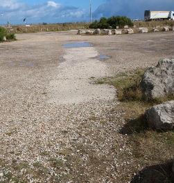
The route of the pipe across the car park is marked by a concrete covering. At each end there are metal covers for the control valves.

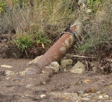
The landshore bank has eroded over the 80 years and exposed the pipe as it leaves the bank and enters the mud.
The route down the beach under the pebbles can still be faintly seen in aerial pictures but it becomes much more obvious where it passes under the green area on the beach.
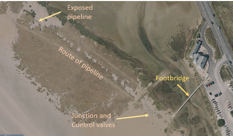
Note that the route of the pipeline is under the low grassy bank. The line of holes in the vegetation is believed to be where the pebbles were scooped up to cover the pipe. There are two exposed sections of pipe at the northern end of the grassy area by the remains of a pillbox. At the southern end there are a number of control valves set in rough concrete bases.
The original pipe then continues in a ridge of pebbles to the edge of the tidal lagoon.
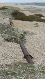
The exposed section of pipe on the edge of the grassy area
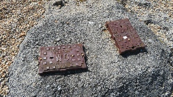
Some of the control valves near the end of the footbridge.
At the point where the pipe crosses to the car park a section has been removed and left laying on the beach. This is to allow water to enter and leave the lagoon.
The later pipeline that goes direct to the pumping station in Victoria Square on Portland joins where the control valves are located near the end of the footbridge. This pipe is buried deeper than the original pipe and its route is now more difficult to trace.