
|
Canns |
Deep indentations in the back of Chesil Beach caused by seawater flowing through the beach during storms. This pushes the pebbles out into the Fleet and leaves the hollows. The spelling has appeared as 'can' or 'cann'. |
|
Car parking |
Car parks adjacent to the beach can be found at Chiswell, Ferrybridge, Abbotsbury, West Bexington, Cogden, Burton Hive and West Bay. The only car park adjacent to the Fleet is at Ferrybridge. |
|
St Catherines Chapel SY57238483 |
a 14th century pilgrimage chapel located on Chapel Hill. Also used as a seamark because of its prominent position. This use was enhanced by placing a light in the turret. The chapel is dedicated to Saint Catherine of Alexandria, the patron saint of virgins, and also of wheelwrights and mechanics. The chapel is now looked after by English Heritage and more information is available by clicking here. |
|
Chapel Hill SY572848 |
Located south of Abbotsbury near the Upper Fleet. St Catherines Chapel is located on top of Chapel Hill. There are excellent views of the Fleet and surrounding area. Access is via a footpath from the centre of Abbotsbury near the Post Office. |
|
Chesil Cove |
The area of Lyme Bay adjacent to Chiswell at the southern end of Chesil Beach. |
|
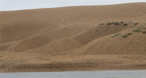
Chesters Hill SY586834 |
A 55 metre high hill south- |
|
Chickerell SY645806 |
A small town along the B3157. Originally a farming and fishing village it has grown considerably in recent times and has a large industrial estate. More information from the town's website or the town council website. |
|
Chickerell Hive Point SY637791 |
The promontory between Tidmoor Point and Butterstreet Cove in the mid- |
|
Chiswell |
The community at the southern end of Chesil Beach on north Portland. Originally called Chesilton. For more information and a good selection of pictures look at the Portland Museum website. |
|
Clay Hard Point SY605817 |
A promontory in the upper Fleet located north of Langton Hive. |
|
Coastal footpath |
The South- |
|
Coastguard |
During the days of sailing ships there was a strong coastguard presence along Chesil Beach with lookouts and cottages at Chiswell, Wyke Regis, Chickerell Hive, Langton Hive, Abbotsbury, East Bexington, Burton Bradstock and West Bay. |
|
Cogden Beach SY502881 |
Located between Burton Mere and Burton Bradstock in the northern part of Chesil Beach. There is a car park on National Trust land nearby, but it is a steep walk over rough ground to the beach. The beach is much used by anglers. |
|
Control Tower |
During WW2 part of Chesil Beach was used as a bombing and firing range. A control tower was built on the beach opposite Chickerell Hive Point. This was tall enough to see over the beach into Lyme Bay and see the seaward range area as well as the Fleet area. This tower continued in use until the late 1950's when it was replaced with a new tower on top of Seabarn Hill. This tower continued in use until the mid- |
|
Court Leet |
Portland has one of the few remaining Court Leets. It was a judicial system set up as part of the manorial and Hundreds system to administer local justice. Their powers waned with time but were not formally removed until 1977. The few remaining Court Leets were mostly ceremonial but also looked after Crown Commons on behalf of the Crown Estate. The Portland Court Leet looks after the common land on Hamm Beach and Chesil Beach. For a fuller explanation look here. |
|
Crook Hill SY643797 |
A 60 metre high hill to the south of Chickerell. The east side has been dug away to form a clay pit for the nearby brick works. There is a footpath across the top of the hill with excellent views of the Fleet and Weymouth Bay. |
|
Crown Estate |
A major property management company that owns Hamm Beach and the southern end of Chesil Beach. |