Chesil Beach and the Fleet Lagoon
18 miles and 180 billion pebbles


Copyright Chesil Multi-
Last updated 5/11/25
This page provides a brief description of the complex geology under Chesil Beach, The Fleet and Hamm Beach. References given at the end of the page should be consulted for a more detailed explanation.
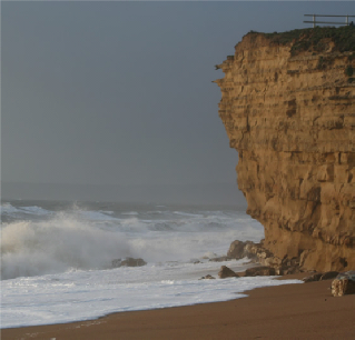
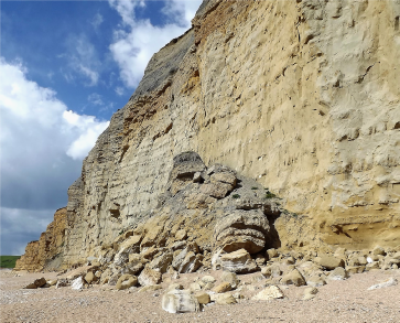
At the northern end of Chesil Beach the cliffs are a distinctive yellow colour arising from the Bridport Sandstone. It has a characteristic banded appearance with different bands weathering at different rates, which often results in undercutting of the cliffs. This causes the frequent rock falls in this area. Picture 1 shows the cliff at Burton Hive Beach and illustrates the undercutting that can occur. The sandstone is capped with inferior oolite between Burton Hive and Freshwater and this in turn is capped with Frome clay.
At Burton Hive Beach there is a fault line with at least 40 metres vertical movement. This fault line is sometimes exposed on the beach near the cafe after a major storm.
This allowed the fold features known as the Weymouth Anticline to be partially eroded resulting in a range of rocks being exposed. The fold, a dome-
The Alpine Orogeny was the mountain-
The erosion has resulted in the exposure of rocks duplicated to the north and south of the fold axis at Langton Herring. Chesil Beach covers the rocks on the seaward side of the Fleet, but they are occasionally exposed following major storms such as in 2014 when the Kimmeridge clay under the beach at Chiswell, Portland, was exposed (see Picture 19 below).
The rocks exposed on the Fleet landward shoreline range from 168 million years old (Frome Clay Formation) to 152 million years old (Kimmeridge Clay). The succession of rocks is best seen from the coast path south of Rodden Hive. North of this point the coast path diverts inland.
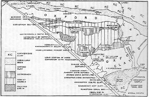
Geology map of the Fleet. (Derived from the geological memoir Geologyof the Country around Weymouth, Swanage and Lulworth. Geological Survey of Great Britain, 1947.)
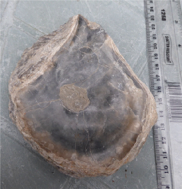
At Langton Hive Point an oyster bed (lumachelle) is exposed within the Frome Clay, formerly known as Fullers Earth Clay (see Picture 4). The main fossil found is the oyster Ostrea hebridica (see Picture 5). Further south on the north side of Herbury Gore another fossil bed is exposed, the boueti bed, with many brachiopods, Rhynchonella boueti (Picture 6).
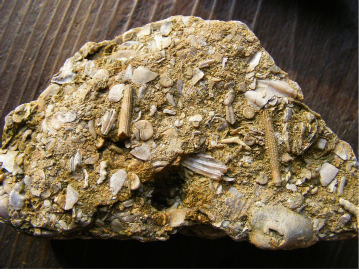
The next rock in the succession is the Forest Marble and this can be seen on the foreshore by the Moonfleet Hotel. Forest Marble is very fossiliferous with fragments of a variety of fossils. In Picture 7 there are echinoid spines (sea urchins), crinoid ossicles (sea lilies, related to sea urchins and starfish) as well as a variety of bivalves (oysters). It is thought that it was formed in a shallow marine environment, possibly coastal, experiencing high energy conditions due to wave action which broke up the organisms that are now preserved as fossils.
Nearby there is an exposure of rock with trace fossils(tracks and trails) from animals that crawled over the sea floor but are not preserved (Picture 8). There are also what are called sedimentary structures such as ripple marks formed by currents or tides in shallow water. These are similar to sand ripples on a beach.
Further south along the Fleet landshore in Butterstreet Cove there are exposures of the next younger rock on the succession called cornbrash (Picture 9). This rock contains fossils but they are not very well preserved. However, it does demonstrate a feature called honeycomb weathering (Picture 10) due to it being rich in carbonates which are attacked by the acid naturally present in rain. The cornbrash is in a very exposed position on the foreshore
In Picture 9 you may also observe that the strata is dipping gently to the left (south) as it is on the southern side of the anticlinal fold.
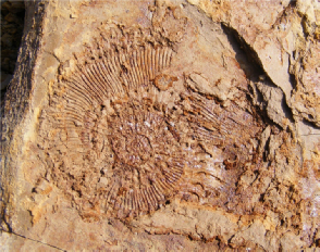
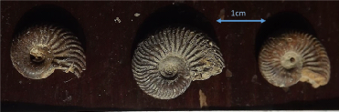
Further south at Chickerell Hive Point there are exposures of Oxford Clay. Here the clay splits into thin layers along the bedding planes and form what is known as a shale. This clay was exploited in the past at Crookhill brickworks. The manufacture of bricks ceased in 1969. This part of the rock succession is organic rich and this helped in the firing of the bricks. Fossils found include the ammonite Kosmoceras (Picture 11) as well as small bivalves. The shape seen is an impression of the shell, the shell itself has been lost through geological processes.
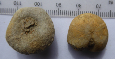
Another feature of the Oxford Clay south of Chickerell Hive Point is large concretions called septarian nodules (Picture 12). These formed in the sediment below the sea floor and are made of calcium carbonate. When pure it forms white crystals of calcite, a polymorph of calcium carbonate. The concretions can be up to a metre across and are left weathered out on the beach because they are stronger than the clay. Examples of septarian nodules can be seen in Portland Museum.
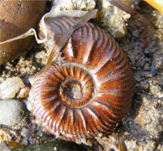
At Tidmoor Point south of Chickerell Hive there are more exposures of Oxford Clay where pyritised ammonites, especially Quenstedtoceras (Picture 13) can be found as well as small belemnites and crinoid fragments (ossicles). The clay slumps onto the beach and wave action washes out the fossils.
In Lynch Cove more Oxford Clay is exposed and another species of Quenstedtoceras can be found (Picture 14). Other common fossils include the oyster Gryphaea.
South of Lynch Cove at the end of Camp Road the next rocks in the succession can be seen: the Corallian and oolitic limestone. This rock formed in shallow sub-
Ripple marks and cross bedding, (tilted layers) as the sediment was moved around in shallow water (picture 16). The beds have trace fossils (worm tubes) and you may find the echinoid Nucleolites (picture 15).
Further south again at Pirates Cove other parts of the Corallian sequence can be seen (Sandsfoot Grit) before reaching the Kimmeridge Clay which is not particularly well exposed but does contain many specimens of the oyster Ostrea delta (Picture 18). These look very similar to modern oyster shells
From Ferrybridge to Chiswell there is no underlying rock exposed as the Kimmeridge Clay is covered with pebbles and sand. At Chiswell the pebbles are occasionally removed by storm action, as in 2014, to expose the Kimmeridge Clay (Picture 19).
ACCESS
Please note that mention of a site on this page does not mean the site is open to the public. If in doubt consult the Fleet Warden first for current access information.
Further reading
Geology of the Dorset Coast. John C.W. Cope.. A Geologists’ Association guide No. 22. 2nd Edition. 2016. Available here.
Introduction to the Wessex Coast. Ian West. Southampton University website.
Geology of Dorset. Wikipedia page.
Geology of the South Dorset and South-
Picture 1. Undercut cliff at Burton Hive Beach
Picture 4. Oyster bed exposed at Langton Hive
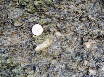
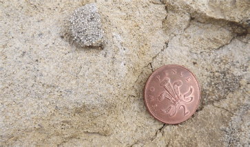
Picture 5. Ostrea hebridica with 10p coin for size.
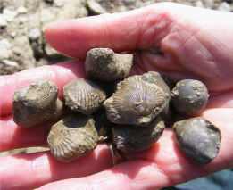
Picture 6. Rhynchonella boueti from Herbury Gore
Picture 7. Forest Marble from near the Moonfleet Hotel with fragments of fossils.
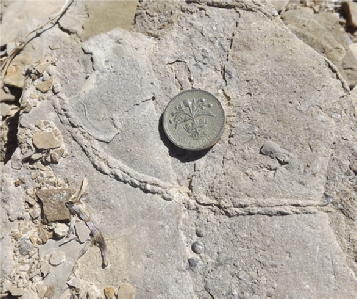
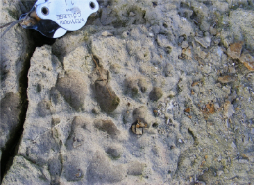
Picture 8. A trace fossil: the trail of a snail with £1 coin for size.
Picture 9. Cornbrash exposed in Butterstreet Cove
Picture 10. Honeycomb weathering of cornbrash.
Picture 11. An ammonite Kosmoceras
Picture 12. A septarian nodule at Chickerell Hive with pencil for size
Picture 14. Ammonites from Lynch Cove.
Picture 13. An ammonite Quenstedtoceras from Tidmoor Point.
Picture 15. Oolitic Limestone showing the spherical grains
Picture 17. Fossilised echinoids Nucleolites.
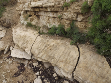
Picture 16. Camp Road exposure showing cross bedding and ripple marks.
Picture 18. Fossilised oyster Ostrea delta from Pirates Cove.
Picture 19. Exposed Kimmeridge Clay at Chiswell after the 2014 storms.
Forest Marble is a limestone that takes its name from the Forest of Wytchwood in Oxfordshire where it was first quarried. A good sample can take a polish like true marble.
Cornbrash gets its name because it easily breaks up into loose rubble and forms a good soild for growing cereals such as corn.
Oxford clay is found under most of southeast England. It is quarried around Oxford and used to make London bricks,
Ooids are formed when a seed particle, such as a grain of sand or shell fragment, is rolled around the seabed while acquiring a coating of calcite. The longer they move around, the larger they become.
Kimmeridge clay is found across southeast England and out into the North Sea. It is the major oil-
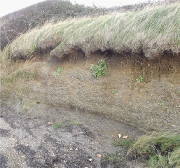
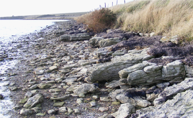
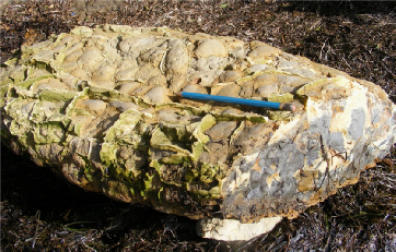
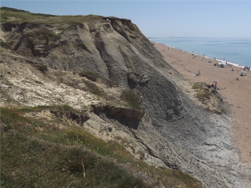
Southwards from Burton Hive the low cliffs are Frome Clay and this can be seen at Cogden Beach (see Picture 3), The Abbotsbury fault reaches the sea NW of East Bexington where the Frome Clay is faulted against the Corallian rocks of the late Jurassic. South of the fault is the Weymouth Anticline.
The underlying geology of the Fleet, the southern part of Chesil Beach and Hamm beach consists of a variety of sedimentary rocks deposited in horizontal layers on the sea floor in Jurassic times between 150 and 170 million years ago. Subsequently the sediments were buried deeply and converted into rock. Later earth movements folded these layers and also uplifted them to be above sea level.
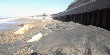
Picture 2, A cliff fall at Burton Cliff
Picture 2 shows a cliff fall at Burton Cliff. The undercutting has resulted in a large portion of the cliff collapsing onto the beach. The large solid lumps of inferior oolite can be seen and the slide is topped with the Frome Clay.
Picture 3. The Frome Clay at Cogden Beach
The information on this page and most of the photographs have kindly been provided by Alan Holliday.
| Access |
| Safety |
| Description |
| Formation |
| Pebbles |
| Description |
| Formation |
| Designations |
| Railway |
| Gallery |
| Postcards |